Plectrum Press
Annotated digital editions of public-domain ethnographies: the text reproduced as printed, with its entities — people, places, rivers, species, institutions — identified and cross-referenced, native-language forms indexed, and the whole linked outward to modern databases, taxonomies, and gazetteers.
My aim is to dignify the primary sources in a world of increasingly mediated and interpolated knowledge.
Jesup North Pacific Expedition
-
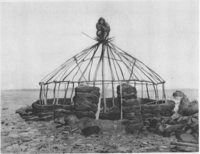
Chukchee Winter House at Mariinsky Post in Course of Construction. Plate XV, Fig. 3.
Sources: The Chukchee
The Chukchee, read from the scans in the American Museum of Natural History Digital Library, digitallibrary.amnh.org/items/91a87fd0-5989-4f79-b2ff-a939ef5533aa.
Third-party geodata, licensed by its own publishers and not by this edition. The shapes in edition/geo/ and the coordinates on the records in entities/ derive from the seven sources below. Two of them oblige attribution, one is share-alike, one is unsettled, and three ask for nothing — and the three are listed anyway, because a source list that named only what it was compelled to name would be an accounting of obligations rather than of provenance. edition/geo/SOURCES.md carries the detail and the one live question.
Atlas of the World's Languages, 2nd edn., ed. R. E. Asher and Christopher J. Moseley, Routledge 2007; traditional speaker areas via Glottography asher2007world. Licensed CC BY 4.0, attribution required. Drawn as the langarea: shapes.
GeoNames, geonames.org, country dumps RU and US. Licensed CC BY 4.0, attribution required. The source of the geo: coordinate on every entity record carrying a link: geonames: identifier beside it.
Global Watersheds, mghydro.com, over MERIT-Hydro and HydroSHEDS. Dual-licensed CC BY-NC 4.0 or ODbL 1.0. Which branch this edition takes is unsettled and is recorded as open in edition/geo/SOURCES.md rather than answered here: the first forbids commercial reuse by anyone who clones this, the second is share-alike on the database. A rights statement quietly asserting one of them would be the overclaim this whole block exists to avoid. Drawn as the watershed: shapes.
OpenStreetMap, openstreetmap.org, © OpenStreetMap contributors. Licensed ODbL 1.0, attribution required and share-alike on a derived database. Consulted as one of the two cross-references behind every hand-located geo: point — 36 entity records name it, and each says so in its own gloss. Whether that extraction is substantial enough to engage the share-alike term is the same unsettled question the watersheds raise, and is deliberately not answered here.
Wikidata, wikidata.org. Dedicated CC0 1.0; no attribution required. Named because it is the source of the geo: coordinate on every record carrying a link: wikidata: identifier, and a coordinate whose origin is not written down is what the provenance ranks exist to prevent, whatever the licence permits. Also the source of each entity card's picture, as the item's P18.
Wikimedia Commons, commons.wikimedia.org. Entity pictures are shown from Commons and are not part of this edition. Each carries its own licence (public domain, CC0, CC BY, CC BY-SA or copyrighted free use), recorded with its author in edition/entity-images.json and printed beneath the picture.
Operational Navigation Charts, US Defense Mapping Agency / National Geospatial-Intelligence Agency; scanned sheets at the University of Texas Perry-Castañeda Library Map Collection, maps.lib.utexas.edu/maps/onc/. A work of the United States Government and so uncopyrighted; no attribution required. Named because it is the largest single source of coordinates in this edition — the roughly thirty points a human read off it by hand, each recorded in the gloss of the record that carries it. The sheets consulted are C-7, C-8, D-8, D-9, D-10 (southern Kamchatka) and E-10 (Bering Strait); the maritime gazetteer is very nearly all C-8.
Natural Earth, naturalearthdata.com, 1:50m physical and 1:10m label vectors. Public domain; no attribution required. Drawn as the base:, region: and marine: shapes.
Licences: The Chukchee
CC0 1.0 Universal. Applies to the transcribed text of the source: the contents of p, note, foreign and other text-bearing elements in the page files, and the caption readings in data/readings.md. The underlying work is in the public domain and this edition asserts no new right over its reproduction.
Creative Commons Attribution 4.0 International. Applies to the editorial apparatus: the TEI encoding and structural decisions, the provenance and adjudication notes, edition/loi.json, edition/toc.json, edition/authorities.json and their research, the entity records and trigger vocabulary in entities/, the indices, and the annotation layer.
The two are separable in principle and interleaved in practice. Where a reuse cannot separate them, treat it as CC BY: attribution costs the reuser nothing the CC0 grant was meant to save them.